

 Google Map of Tabisar
TABISAR IS A TOWN AND UNION COUNCIL ISAKHEL TEHSIL MIANWALI DISTRICT, PUNJAB, PAKISTAN AND IS LOCATED AT 33 08’50.97 N 71°33 40.69 E AND HAS AN ALTITUDE OF 686 M (2250 FT).


TOTAL POPULATION OF TABI SAR
AS PER CENSUS 2010 WAS = 25147
POSE BHANGI KHEL SHARQI = 11759
LONDY BHANGI KHEL = 5907
KUTCH TUNDAR KHEL = 7481
Union Council Office of Tabisar


 HAND MADE MAP OF UC TABISAR MIANWALI


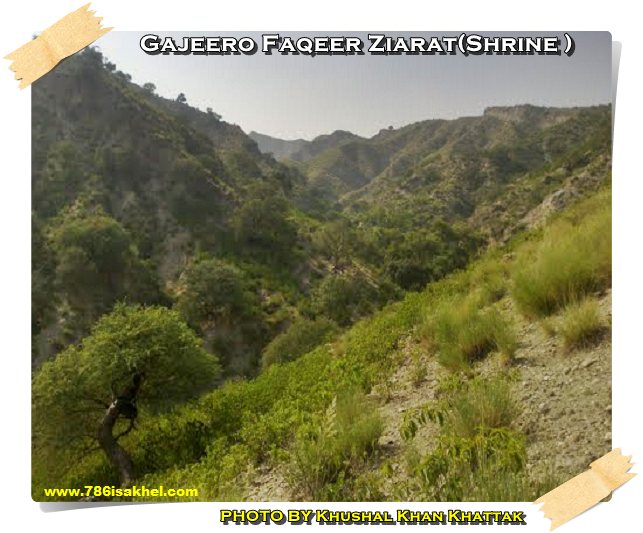
Gajeero Faqeer Ziarat (Shrine ) Tabbi Sar
By:- Khushal Khan Khattak Basically this place was famous for the Gajeero Faqeer Ziarat(Shrine ) but gradually the spot became a picnic place. It is situated in mountainous area, covered with greenery. People from adjacent areas of Karak ,Shakardara and Mianwali visit this amazing spot in leisure. Approximately 3 Km Jeep able road is available up to this spot from Naryub Market Kohat Kalabagh Road. Geographical coordinates of the shrine are 33? 08’ 35.85” North and 71? 31’ 37.00” East, Elevation 2600 feet above sea level. Even elevation of some nearby mountain peaks is 3000 feet above sea level. From these top of hills, with the help of binoculars, one can see and enjoy the far-flung area and surrounds which give a beautiful look and sense
 Contributors Of data and information about Tabisar
Special Thanks
 If You have any Data,Information and pictures about
TABISAR
please send it at -786isakhel@gmail.com


KAMAR MUSHANI


KHAGLAN WALA

Sultan Khel, Isa Khel Mianwali — Tareekh, Tehzeeb aur Maujooda Halaat


TOLA BHANGI KHEL

TEHSIL ISAKHEL KE DIHH O QSBAT KA TAARUF. BALAJ JISL KE QALAM SE

The Khattak Belt A Comprehensive Profile -Isa Khel Tehsil

TOLA MANGALI

KOTKI BAIRONI -ISA KHEL – Historical Background & Overview


